COLTON’S POCKET MAP of WYOMING COLORADO and UTAH 1877
$4,500.00
COLTON’S POCKET MAP of WYOMING COLORADO and UTAH 1877
COLORADO ARTIFACTUAL
Description
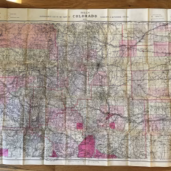
COLTON’S (Pocket) MAP OF WYOMING, COLORADO and UTAH, published 1877
Publisher: G. W. and C. B. Colton, 1877
Copyright: 1876
172 William Street, New York
This is an original “pocket map,” not a sheet from an atlas. It was designed to be folded and fit inside gold-printed, black-cloth covers, as is this specific Colton map.
Folder dimensions: 3-3/4 inches by 5-3/4 inches
Map dimensions, unfolded: 25-3/4 inches by 17-1/4 inches
Excellent condition, as if never used. Beautiful, vibrant colors. Pin-point detail. Topographical, as well as roads, railroads, watercourses, and wagon routes.
WYOMING TERITORY. UTAH TERRITORY. COLORADO TERRITORY/STATE.
Many institutions list the “atlas sheet” in their collections; however, few have the original “pocket map” in their archives.
COLORADO ARTIFACTUAL